RO - 2024: Country Fiche
Table of Contents
Introduction
The INSPIRE Directive sets the minimum conditions for interoperable sharing and exchange of spatial data across Europe as part of a larger European Interoperability Framework and the e-Government Action Plan that contributes to the Digital Single Market Agenda. Article 21 of INSPIRE Directive defines the basic principles for monitoring and reporting. More detailed implementing rules regarding INSPIRE monitoring and reporting have been adopted as Commission Implementing Decision (EU) 2019/1372 on the 19th August 2019.
This country fiche highlights Romania’s progress in the various areas of INSPIRE implementation. It contains information covering the period January to December 2023.
State of Play
The following paragraphs provide a summary of currently valid information on governance, use, impacts and progress achieved towards INSPIRE implementation.
Coordination
National Contact Point
- Name of Public Authority: Ministry of Development, Public Works and Administration National Agency for Cadastre and Land Registration
- Postal Address: 202A, Splaiul Independenței St., 1st floor, Sector 6, Bucharest
- Contact Email: inspire@ancpi.ro
- Telephone Number: +40 21 317 73 39
- Telefax Number: +40 21 316 52 24
-
National INSPIRE Website: www.geoportal.gov.ro
- MIG Contacts:
- Contact Person: Ioan Laurențiu RĂILEANU
- Email: ioan.raileanu@ancpi.ro
-
Telephone Number: +40 735 950 587
- Contact Person: Laura BOLOCAN
- Email: laura.bolocan@ancpi.ro
- MIG T Contacts:
- Contact Person: Laura BOLOCAN
- Email: laura.bolocan@ancpi.ro
-
Telephone Number: +40 740 657 710
- Contact Person: Gabriela MAGEARU
- Email: gabriela.magearu@ancpi.ro
Coordination Structure & Progress:
Coordination structure
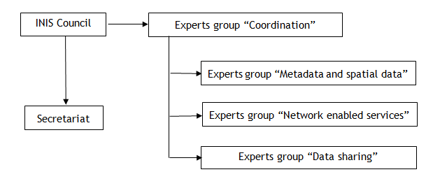
Romania has transposed the INSPIRE Directive since 2010 by developing a normative act called The Government Ordinance nr. 4/2010 on the establishment of the National Infrastructure for Spatial Information in Romania that was updated in 2014. This normative act establishes the legal framework for the establishment of the coordination structure, the National Infrastructure for Spatial Information Council (INIS Council), composed of representatives of 21 national public authorities.
The Presidency and Secretariat of the INIS Council are provided by the National Agency for Cadastre and Land Registration (ANCPI), while the Vice-President is provided by the Ministry of Environment, Water and Forests. As shown above, the INIS Council is assisted in its work by 4 expert groups.
Progress
The expert groups have continued their specific work to support public authorities in the implementation of INSPIRE. On the INIS geoportal of Romania, www.geoportal.gov.ro, information about the National Infrastructure for Spatial Information in Romania is available, providing access for the public and private sector users.
Improvements were observed in the data exchange compared to the previous year. This is also due to the fact that the spatial data infrastructure is constantly being updated. Analysing the results of the monitoring process of spatial data sets and services for the year 2023, there is an increase in the indicators regarding the monitoring of the metadata compliance for the data sets, in the accessibility of the spatial data sets through view and download services, and a stagnation of the indicators regarding monitoring the compliance of spatial data sets, the availability of spatial data and services, and the compliance of network services.
Functioning and coordination of the infrastructure
The Ministry of the Environment, Water and Forests (MMAP) carried out during 2023 the project Services for update and publication of INSPIRE data sets, and published on the national geoportal (INIS) and implicitly on the European INSPIRE geoportal 11 data sets, each of them having view and download services INSPIRE compliant. These datasets correspond to themes I.9 Protected areas, III.17 Biogeographical regions, III.18 Habitats and biotopes and III.19 Species distribution. The Ministry of Internal Affairs (MAI) carried out the following activities during 2023: updating the metadata related to the spatial data set corresponding to theme III.12 Natural risk areas as well as the related view and download services, carrying out activities for harmonization and ensuring the interoperability of the spatial data sets and services, updating capabilities of services and information related to dataset, according to the Services Technical Guide. The Ministry of Development, Public Works and Administration (MDLPA) carried out activities to create the data set corresponding to theme III.4 Land use. Thus, MDLPA created an interactive application for the publication of General Urban Plans. Up to now, 1935 Territorial Administrative Units compared to 1926 at the level of 2022, have sent urban planning documentation in various digital formats, without a standardized structure. Emphasis is placed on the collection of all documentation, especially zoning plans and urban regulations containing information on land use. The application is an integral part of the Territorial Observatory IT platform, managed by MDLPA and can be accessed at https://arcg.is/1mufSnO. In 2023, MDLPA developed a legislative act amending and supplementing Law no. 350/2001 regarding territorial planning and town planning and on the development and updating of town planning documentation, (Order no. 904/2023) regarding the Technical Norms regarding spatial data sets related to town planning documentation. A tool was created for the collection and validation of urban planning documentation developed in standardized GIS format (geopackage) according to the specifications of the technical guide for the realization of theme III.4 Land use, in accordance with the provisions of this Order.
Usage of the infrastructure for spatial information
The public authorities in Romania download from the INIS geoportal, the INSPIRE compliant dataset related to the theme I.4 “Administrative Units”, based on an open data license. In order to avoid overlaps of spatial data public procurement and multiplication of the costs for collecting spatial data, it was created in the INIS geoportal, the National Projects application, which aims to record projects that produce spatial data financed from public funds, by uploading the project coverage area, followed by filling in the information related to the project. At the time of drafting this document, projects from 5 public authorities were uploaded. The spatial data under theme III.12 ”Natural risk zones” were used in the specific activities of local public authorities.
Data Sharing Arrangements
The public authorities in Romania conclude collaboration protocols to share the spatial data they hold. This includes not only the INSPIRE data, but also the spatial data that belong to the national infrastructure in Romania. Spatial data in national format, within the Download Applications within the INIS geoportal shall be provided on the basis of open licenses.
Costs and Benefits
The implementation of INSPIRE is a first step towards using geospatial information in a unitary and coherent way, thus avoiding data duplication. The INIS geoportal facilitates the discovery of data for the development of which common standards have been used to enable interoperability between public authorities and Member States, as well as sharing and reuse of data using a common infrastructure. According to Commission Implementing Regulation (EU) 2023/138 establishing a list of specific high-value data sets and the arrangements for their publication and re-use, it was found that of the 34 INSPIRE themes, established in the annexes I, II and III of Directive 007/2/EC, 27 themes contain high-value datasets belonging to the fields: geospatial, Earth observation and environment, meteorological and mobility, fields defined under Directive (EU) 2019/1024 2019 on open data and reuse of public sector information. Thus, the implementation of INSPIRE represents a considerable benefit for the implementation of the Open Data Directive.
Key facts and figures
Key facts and figures from monitoring 2023 can be found at: https://inspire-geoportal.ec.europa.eu/catalog/views/inspireportal/monitoringreporting/site/mr2023_details.html?country=ro.